Discrete Mapping Using a .csv File and System
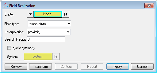
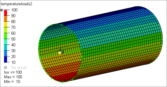
This task is an example of mapping using data from a .csv file.
- Proximity
- Linear Interpolation
- Inverse Distance
- Triangulation
View new features for HyperMesh 2019.
Learn the basics and discover the workspace.
Discover HyperMesh functionality with interactive tutorials.
Solver interfaces supported in HyperMesh.
A solver interface is made up of a template and a FE-input reader.
Collectors are named organizational containers for collected entities. Collected entities are nameless entities which must reside within one, and only one, collector. Collected entities are mutually exclusive to a collector.
Entities which are given a name but are not collected or organized into containers.
Accelerometer entities measure acceleration in the simulation.
Ale Fsi Projection entities provide a coupling method for simulating the interaction between a Lagrangian material set (structure) and ALE material set (fluid).
Ale Reference System Curve entities defines a motion and/or a deformation prescribed for a geometric entity, where a geometric entity may be any part, part set, node set, or segment set.
Ale Reference System Group entities used to associate a geometric entity to a reference system type.
Ale Reference System Node entities defines a group of nodes that control the motion of an ALE mesh.
Ale Reference System Switch entities allows for the time-dependent switches between different types of reference systems, that is, switching to multiple PRTYPEs at different times during the simulation.
Ale Smoothing entities constraint keeps an ALE slave node at its initial parametric location along a line between two other ALE nodes.
Ale Tank Test keyword provides curve through an engineering approximation when control volume airbags only require two engineering curves to define gas inflator and those two curves can be experimentally measured but the ALE inflator needs one additional state variable - the inlet gas velocity which is impractical to obtain.
Block entities are enclosed volumes represented by a "box" or block.
Body entities define a kinematic assembly made of FE parts or nodes.
Box entities are enclosed volumes, which are represented by a box.
Constrained extra node entities define and store the keywords *CONSTRAINED_EXTRA_NODES_NODE and *CONSTRAINED_EXTRA _NODES_SET.
Constraint entities define kinematical constraints on a body at a specified node or point location.
Contact surface entities define and store contact definitions typically used in contact analysis.
Control volume entities define and store control volumes typically used in safety analysis.
Cross section entities store cross section definitions used in a crash analysis.
Curve entities define and store xy data and are associated with a plot entity.
Dummy entities are defined by bodies representing the different kinematic assemblies of the dummy.
Element clusters are used to describe an assembly of elements for post-processing and failure control.
Failures describe material failure criteria to be coupled to material models.
Feature entities track and manage certain geometric features.
Field entities store spatially varying values, which can later be realized (mapped) to the element and node data of a new target mesh.
In this topic you will learn how to create fields.
In this topic you will learn how to realize, or map, fields.
The following tasks show examples of various mapping strategies.
This task is an example of how to map fields.
This task is an example of discrete mapping of temperatures or pressures.
This task is an example of mapping using data from a .csv file.
This method is useful when transferring data from existing solver decks (.bdf, .fem, .inp, and so forth) to new meshed models. Old mesh shape functions are used with this method.
Use 1D source element data (results and current model with .csv) to map to 2D/3D target elements.
3D linear or quadratic source element data can be mapped to 2D/3D target elements. 3D source elements can have loads or results which can be mapped.
These tasks will introduce you to the various mapping types.
Generic field mapping (table mapping) uses matrix columns (source data) to map and export target elements to a new Excel table.
When source data is not in the correct location and overlaps with the target model, the tools provided in the Field Realization dialog can be used to transform the source model to the target model's location with linear transformation, rotation, or scale methods.
Perform nodal force balance mapping using OptiStruct to ensure mapped target nodal forces and source nodal forces are in equilibrium.
Group entities define and store interfaces and rigid walls typically used in contact analysis.
Hourglass entities define hourglass and bulk viscosity properties which are referenced via HGID in the *PART command.
Interface Component entities create an interface in interface file for use in subsequent linking calculations.
Interface Linking Discrete keyword link node(s) to an interface in an existing interface file.
Joint entities define the kinematic relationship between two bodies (for Ball, Cylinder, Revolute, Slider joints) or three bodies (for DoubleSlider joints).
Laminate entities define laminates, which make up a laminated structure by defining the stacking sequence of ply entities that make up the laminated structure.
Load step entities define and store load cases for a given analysis.
Material entities define and store material definitions for a model.
Mechanism entities are the root of the hierarchy in the Mechanism Browser.
Output block entities define and store solver output requests.
Parameter entities parameterize FE entity and geometric entity attributes.
Ply entities define a FEA ply which is the FEA correlation to a physical ply.
Plot entities associate and organize curve entities within a xy plot window.
Position entities allow you to apply a Transformation sequence on set of nodes or SolverSubmodels.
Pretensioner entities define pretensioners.
Property entities define and store 1D, 2D, and 3D property definitions for a model.
Region entities store information used to facilitate and automate modeling practices and processes. It enables a selection which can be common across design changes or other models, provided region data is the same.
Retractor entities define retractors.
Rigid wall entities provide a method for treating a contact between a rigid surface and nodal points of a deformable body. In the LS-DYNA and Radioss user profiles, rigid walls can be created in the Model and Solver browsers.
Sensor entities define and store sensors typically used in safety analysis.
Set entities define and store lists of entity IDs for entities, sets of sets, or lists of set IDs.
Slip ring entities define sliprings.
Solver masses are used to model lumped mass finite element mesh.
Table entities collect data points.
Tag entities tag a piece of information, called the body, onto a node, element, line, surface, point, or solid within the model.
Termination entities provides an alternative way to stop the calculation before the termination time is reached.
Title entities attach a title box with text to the modeling window, or to a node, element, load, or system.
Transformation entities define solver transformations, and are used to define a transformation sequence in a Position entity, to be applied on a set of nodes or on a SolverSubmodel.
Entities used for morphing the shape of FE model.
Entities used to set up optimization problems.
Control card entities create solver control cards such as results file I/O options, CPU and memory limits, and others.
Undefined entities are entities that will not be written to the solver deck.
The encryption of solver entities is used to translate entity data into an undisclosed language.
Element property and material assignment rules are based on the current user profile (solver interface).
Supported cards organized by solver.
Support provided by the CAD readers and writers.
Browsers supply a great deal of view-related functionality in HyperMesh by listing the parts of a model in a tabular and/or tree-based format, and providing controls inside the table that allow you to alter the display of model parts.
Pre-processing and post-processing tools are displayed on panels located at the bottom of the application.
Create and edit geometry.
Learn about the different types of mesh you can create in HyperMesh.
Create connections between parts of your model.
Create, organize, and manage the CAE parts.
Perform automatic checks on CAD models, and identify potential issues with geometry that may slow down the meshing process using the Verification and Comparison tools.
Tools used for crash and safety analysis.
Overview of how to build a finite element model.
Morph the shape of your finite element model.
Setup an Optimization in HyperMesh.
Convert finite element models to another solver format.
Study relationships between data vectors in results files.
Learn how to use post-processing functions.
A solver interface is made up of a template and a FE-input reader.
Entities which are given a name but are not collected or organized into containers.
Field entities store spatially varying values, which can later be realized (mapped) to the element and node data of a new target mesh.
The following tasks show examples of various mapping strategies.
This task is an example of mapping using data from a .csv file.
This task is an example of mapping using data from a .csv file.


(c) 2019. Altair Engineering Inc. All Rights Reserved.